i-75 Florida Traffic Maps

  • Alachua

  • Apollo Beach

  • Bee Ridge

  • Bonita Springs

  • Bradenton

  • Brandon

  • Bushnell

  • Cape Coral

  • Charlotte Harbor

  • Charlotte Park

  • Coleman

  • Cooper City

  • Ellenton

  • Ellisville

  • Estero

  • Everglades

  • Fort Myers

  • Gainesville

  • Gibsonton

  • Golden Gate

  • Harbour Heights

  • Harbour View

  • High Springs

  • Jennings

  • Lake City

  • Lake Panasoffkee

  • Land O' Lakes

  • Laurel

  • Mango

  • Marion Oaks

  • Mason

  • Miami Lakes

  • Micanopy

  • Miramar

  • Naples

  • Nokomis

  • North Port

  • Ocala

  • Orient Park

  • Osprey

  • Palm River

  • Palm Springs N.

  • Pembroke Pines

  • Port Charlotte

  • Punta Gorda

  • Punta Gorda South

  • Reddick

  • Ridge Manor

  • Riverview

  • Ruskin

  • San Antonio

  • San Carlos Park

  • Sarasota

  • Sarasota County

  • Solana

  • Sumterville

  • Sun City Center

  • Tampa

  • Temple Terrace

  • Three Oaks

  • Tice

  • Tropical Gulf Acres

  • Venice

  • Wesley Chapel

  • Weston


  • SEE MORE i-75 FL Traffic Maps


    Interstate 75 Florida
    Google


    I-75 Florida Traffic Maps ...
     
    Click highlighted city names for local traffic conditions maps ...

    Interstate 75 Florida Map

    See Full
    i-75 FL Traffic Maps Directory


    SEE ALSO:

    i-75 News Blog ...


    i-75 Weather ...


    About I-75 Florida ...
     
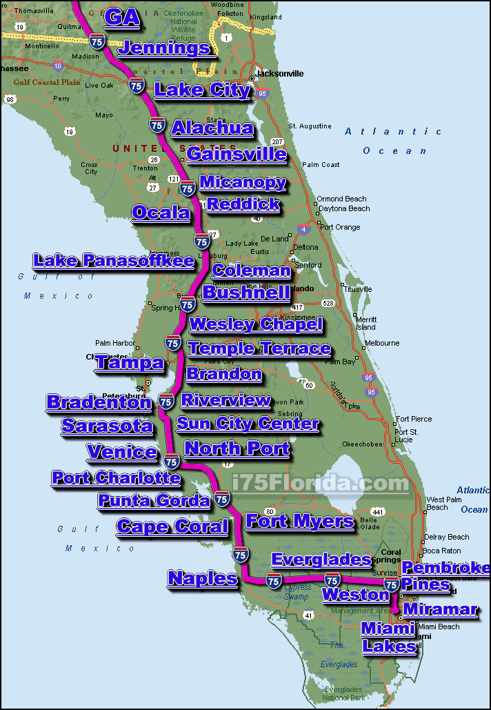
    The Interstate 75 in Florida is the main north-south automotive & trucking transportation corridor for the west coast of Florida.

    The i-75 in Florida runs mostly in a north-south direction along the western coast of Florida (passing through the metropolis of Tampa), however, near the south-western section of the i-75 (around Naples) , the Interstate Highway turns east and travels across the southern portion of Florida (through/across the Everglades) in a east-west direction to the east coast of Florida where it connects to the the greater Miami area.

    The i-75 connects most of the larger cities located along the western portion of Florida state, some of the cites/communities located along or near the i-75 corridor in Florida include; Alachua, Bradenton, Brandon, Cape Coral, Fort Myers, Gainesville, High Springs, Lake City, Naples, Ocala, Port Charlotte, Punta Gorda, Riverview, Sarasota, Sun City Center, Tampa... see a full list of cities along the i-75 corridor in Florida we currently provide real-time traffic info for.

    The length of the i-75 in Florida at approximately 482 miles long, and requires a continuous driving time of approx. 7 hrs. & 32 minutes to complete.


    Disclaimer & Privacy Policy

    Copyright i75Florida.com